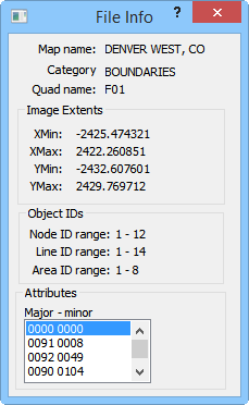
The File Info dialog displays information
about the DLG file.
File Info Dialog
Click the File Info button in the DLG Import Options dialog and the File Info dialog opens.

The File Info
dialog displays information
about the DLG file.
Display Information
The Map name, Category, and Quad name are displayed at the top of the dialog. The base file information is display only.
Image Extents
The XMin, XMax, YMin, and YMax values for the file are displayed.
Object IDs
The Node ID range, Line ID range, and Area ID range are displayed.
Attributes
The Major - minor attributes are displayed. Use the scroll bar to display additional attributes if necessary.
OK
Click the OK button to proceed with the import process.
Cancel
Click the Cancel button to close the dialog without importing.
See Also