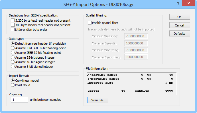
Use the SEGY Import Options dialog to specify options for the imported .SGY or .SEGY file.
The SEGY Import Options dialog allows you to specify the deviations from specification, data type for seismic sample values, point coordinate axes, and coordinate values for an imported .SGY or .SEGY file.
It is possible for SEG-Y files to have zeros or nonsensical values in the trace coordinates. When this is the case, coordinates from 0 to N will be automatically generated. The coordinate scaling information from the trace headers will be applied to the generated coordinates.
SEGY Import Options Dialog
This dialog appears when the File | Import command is chosen and SEG-Y Seismic Data Log (*.sgy, *.segy) is selected as the file type to import.

Use the SEGY
Import Options dialog to specify
options for the imported .SGY or .SEGY file.
Deviations From SEG-Y Specification
A SEG-Y file that conforms to the SEG-Y specification contains a 3,200-byte "reel header" data structure before the rest of the information in the file. However, many SEG-Y files do not conform to the specification in this regard. Check the box next to 3,200 byte text reel header not present if the import file does not contain the 3,200 byte reel header.
A SEG-Y file that conforms to the SEG-Y specification contains a 400 byte binary "reel header" data structure before the rest of the information in the file. However, many SEG-Y files do not conform to the specification in this regard. Check the box next to 400 byte binary reel header not present if the import file does not contain the 400 byte reel header.
A SEG-Y file that conforms to the SEG-Y specification contains data in big-endian byte order. However, many SEG-Y files do not conform to the specification in this regard. Check the box next to Little-endian byte order if the import file contains data in little-endian byte order.
Data Type
The Data type option allows the user to specify the data type for the seismic sample values in the import file.
Select Detect From header or use default for files containing valid headers. Without a valid header, the default data type is assumed.
Select Assume IBM 360 32-bit floating point and specify that the import file has IBM 360 floats unless the file contains a valid header for another type.
Select Assume IEEE 32-bit floating point to specify that the import file contains IEEE floats unless the file contains a valid header specifying another type.
Select Assume 32-bit signed integer to specify that the import file contains 32-bit integer data.
Select Assume 16-bit signed integer to specify that the import file contains 16-bit integer data.
Select Assume 8-bit signed integer to specify that the import file contains 8-bit integer data.
Import Format
The Import format controls specify how the data samples from the import file are structured during the import process. The possible selections are:
Curvilinear model - The traces of seismic samples are loaded as a curvilinear lattice into a Lattice Source module in the Network Manager.
Point Cloud - Each sample is loaded as one point in a Voxler point set. The data is imported into a Point Source module in the Network Manager.
The Z spacing value specifies the number of units between samples. The Z spacing value can be positive or negative. Positive Z spacing values correspond with depth in the SEGY file, i.e. the z value increases as the sample moves "down" geographically. Negative Z spacing values correspond with elevation values in the SEGY file, i.e. the z values increases as the sample move "up" geographically.
If the imported data is oriented incorrectly, try changing the sign of the Z spacing value.
The Spatial Filtering controls the region to be imported. Click the Enable spatial filter check box to specify the minimum and maximum coordinate extents for the imported region.
Type the minimum X (westernmost) value to be imported in the Minimum X/easting field.
Type the maximum X (easternmost) value to be imported in the Maximum X/easting field.
Type the minimum Y (southernmost) value to be imported in the Minimum Y/northing field.
Type the maximum Y (northernmost) value to be imported in the Maximum Y/northing field.
The File Information section displays the X/easting range, Y/northing range, Imported size, Size after spatial filter (if applicable), and the number of Traces and Samples. To view the file information, first correctly specify the Deviations from SEG-Y specification, Data type, and Import format options. Next click the Scan file button. An error is displayed if the import options are not specified correctly.
Click the Defaults button to revert the import options to the default values.
OK
Click the OK button to proceed with the import process.
Cancel
Click the Cancel button to close the dialog without importing.
See Also